TomTom
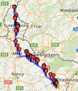
The TomTom Rider 400 is a completely new toy for me. Initially I was quite disappointed that the TomTom software did not support the creation of customised routes. Until I discovered that you should actually use a different tool that you can download for free. Tyre has a somewhat old-fashioned look and feel, but even the free version does what it needs to do: "Put way points on a map and plan the route". It saves the route as an ITN file on the computer, which transfers through the USB cable to the TomTom; so workable that I enthousiastically continued creation of more and more itineraries. 'Cause from Luxembourg we go south into France to a small town called Bœrsch.
We'll be using the scenic route this time. A good thing, because I forgot a few basics about European road travel.
France
We will be going to France. The country where people have perfected the art of protesting to the highest standards. If the underground is running in Paris, you'll probably have a truck drivers' slow-down goings-on on the motorway. If the civil-servants' union goes back to work, the cleaners go on strike.
And we've the French farmers, with their bloackages of the A31 and A4 motorways. Exactly our route...
Weather
Never assume what meteorologists and astronomers call summer, actually is summer. Weather in Northern Europ is predictable for 24 hours at max. And right now, the models expect rain.
This is where I revert to a tool from the world of sailing, ZyGrib. ZyGrib is a French (!) tool which basically downloads raw meterological forecast data (GRIB files). That data is from the American NOAA GFS model, which differs from the model that our own KNMI uses (HIRLAM). But ZyGrib offers detailed local predictions with a 3 hour interval.
For Thursday, KNMI puts a trough and front above Danmark on Thursday, with no significant rain.
Zygrib on the other hand, puts the front over the southern part of NL, with significant showers. Let's hope KNMI is right this time. In both cases we have a pleasant tail wind all the way to Luxembourg.
On board the boat we have these GRIB files as overlay on the GPS plotter. It would be nice to have something similar on the motorcycle. And better with 4G you can do that real time!
 De TomTom Rider is een compleet nieuw speeltje voor me. In het begin was ik aardig teleurgesteld dat de bijgeleverde software niet de mogelijkheid had tot plannen van eigen ritten. Totdat ik ontdekte dat daarvoor een simpel en gratis andere tool is, Tyre. Tyre heeft een ontzettend achterhaalde gebruikers interface, maar zelfs de gratis versie doet verder precies wat je wil: "route punten in de kaart zetten en route plannen." Opslaan van de route doe je in ITN bestandsformaat, en de USB kabel exporteert 'm direct naar de Tom Tom.
Het geheel is zo werkbaar, dat ik enthousiast meer en meer routes ging produceren. Want vanuit Luxemburg gaan we Frankrijk in, naar het plaatsje Bœrsch (klik op kaart voor route in ITN fomat). Dit keer nemen we de toeristische route. Dat is maar goed ook, in mijn enthousiasme was ik een paar basisregels van reizen door Europa vergeten...
Frankrijk
Het land waar protesteren is uitgevonden en geperfectioneerd tot in de details. Als de metro rijdt in Parijs, is er zeker een 'langzaam-aan-actie' van vrachtwagen chauffeurs. Als de ambtenaren net weer aan het werk gaan, starten de schoonmakers hun acties. En wij hebben de Franse boeren, die de snelwegen A31 en A4 gaan blokkeren. Precies onze route...
Het weer
Neem nooit aan dat als meteorologen en astronomen het zomer noemen, het ook zomer is. Het weer in Noord Europa is hoogstens 24 uur van te voren te voorspellen. En nu hebben we een redelijke kans op regen...
Dit is waar ik een programmatje gebruik dat een typisch zeil-dingetje is: ZyGrib. ZyGrib is Frans (!) tooltje, dat ruwe meterologische voorspellingen (GRIB files) download. Die data komt van het NOAA GFS model, dat soms van mening verschilt met onze KNMI (HIRLAM). Maar ZyGrib geeft wel echt lokale voorspellingen met een interval van 3 uur.
Voor aanstaande donderdag zet het KNMI een trog en front boven Denemarken, zonder neerslag van betekenis in onze buurt. Zygrib aan de andere kant legt het front - met bijbehorende buien - precies over onze route. Laten we dit keer dan maar hopen dat het KNMI gelijk heeft. In beide gevallen hebben we een mooi rugwindje naar Luxemburg.
Aan boord van de boot hebben we overigens de mogelijkheid om deze weerkaarten op de GPS plotter over de route heen te leggen. Het zou aardig zijn als dat ook op de TomTom mogelijk was. En met een 4G dataverbinding, moet dat zelfs 'real time' kunnen....
 |
| Click to download ITN for TomTom |
France
We will be going to France. The country where people have perfected the art of protesting to the highest standards. If the underground is running in Paris, you'll probably have a truck drivers' slow-down goings-on on the motorway. If the civil-servants' union goes back to work, the cleaners go on strike.
And we've the French farmers, with their bloackages of the A31 and A4 motorways. Exactly our route...
Weather
Never assume what meteorologists and astronomers call summer, actually is summer. Weather in Northern Europ is predictable for 24 hours at max. And right now, the models expect rain.
This is where I revert to a tool from the world of sailing, ZyGrib. ZyGrib is a French (!) tool which basically downloads raw meterological forecast data (GRIB files). That data is from the American NOAA GFS model, which differs from the model that our own KNMI uses (HIRLAM). But ZyGrib offers detailed local predictions with a 3 hour interval.
For Thursday, KNMI puts a trough and front above Danmark on Thursday, with no significant rain.
Zygrib on the other hand, puts the front over the southern part of NL, with significant showers. Let's hope KNMI is right this time. In both cases we have a pleasant tail wind all the way to Luxembourg.
On board the boat we have these GRIB files as overlay on the GPS plotter. It would be nice to have something similar on the motorcycle. And better with 4G you can do that real time!
 |
| ZyGrib model output. |
De TomTom Rider is een compleet nieuw speeltje voor me. In het begin was ik aardig teleurgesteld dat de bijgeleverde software niet de mogelijkheid had tot plannen van eigen ritten. Totdat ik ontdekte dat daarvoor een simpel en gratis andere tool is, Tyre. Tyre heeft een ontzettend achterhaalde gebruikers interface, maar zelfs de gratis versie doet verder precies wat je wil: "route punten in de kaart zetten en route plannen." Opslaan van de route doe je in ITN bestandsformaat, en de USB kabel exporteert 'm direct naar de Tom Tom.Het geheel is zo werkbaar, dat ik enthousiast meer en meer routes ging produceren. Want vanuit Luxemburg gaan we Frankrijk in, naar het plaatsje Bœrsch (klik op kaart voor route in ITN fomat). Dit keer nemen we de toeristische route. Dat is maar goed ook, in mijn enthousiasme was ik een paar basisregels van reizen door Europa vergeten...
Frankrijk
Het land waar protesteren is uitgevonden en geperfectioneerd tot in de details. Als de metro rijdt in Parijs, is er zeker een 'langzaam-aan-actie' van vrachtwagen chauffeurs. Als de ambtenaren net weer aan het werk gaan, starten de schoonmakers hun acties. En wij hebben de Franse boeren, die de snelwegen A31 en A4 gaan blokkeren. Precies onze route...
Het weer
Neem nooit aan dat als meteorologen en astronomen het zomer noemen, het ook zomer is. Het weer in Noord Europa is hoogstens 24 uur van te voren te voorspellen. En nu hebben we een redelijke kans op regen...
Dit is waar ik een programmatje gebruik dat een typisch zeil-dingetje is: ZyGrib. ZyGrib is Frans (!) tooltje, dat ruwe meterologische voorspellingen (GRIB files) download. Die data komt van het NOAA GFS model, dat soms van mening verschilt met onze KNMI (HIRLAM). Maar ZyGrib geeft wel echt lokale voorspellingen met een interval van 3 uur.
Voor aanstaande donderdag zet het KNMI een trog en front boven Denemarken, zonder neerslag van betekenis in onze buurt. Zygrib aan de andere kant legt het front - met bijbehorende buien - precies over onze route. Laten we dit keer dan maar hopen dat het KNMI gelijk heeft. In beide gevallen hebben we een mooi rugwindje naar Luxemburg.
Aan boord van de boot hebben we overigens de mogelijkheid om deze weerkaarten op de GPS plotter over de route heen te leggen. Het zou aardig zijn als dat ook op de TomTom mogelijk was. En met een 4G dataverbinding, moet dat zelfs 'real time' kunnen....